Record Toccoa River crest floods McCaysville and Copperhill: dozens rescued in the Georgia–Tennessee flash flood emergency, no deaths reported
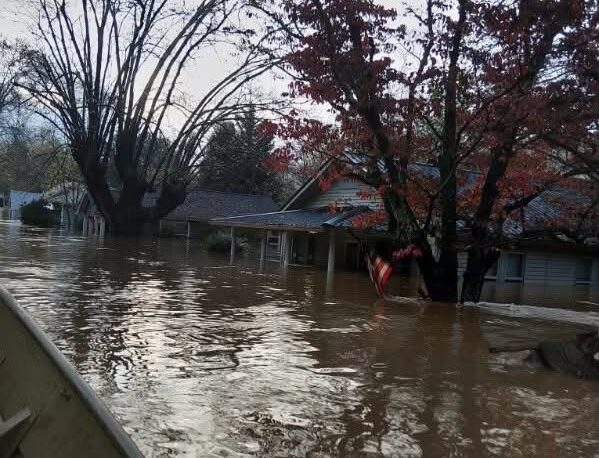
Severe storms late Wednesday into Thursday 5 November 2026 sent the Toccoa River — the Ocoee once it crosses into Tennessee — to a record crest of 18 feet at Copperhill, flooding the twin border towns of McCaysville, Georgia, and Copperhill, Tennessee, under several feet of water and forcing dozens of boat rescues. The National Weather Service declared a flash flood emergency for McCaysville and Copperhill, its rarest warning, and told residents to seek higher ground. McCaysville's police chief said water stood 6 to 7 feet deep in the downtown business district and over rooftops in several areas. Rescue totals are preliminary and differ by source and hour — more than 30 overnight by the police chief's count to AP, about 20 in a county spokesperson's separate estimate, and at least 45 in the latest police figure carried by FOX Weather — so no single total is settled yet. Fannin County's emergency management spokesperson told AP no injuries or deaths had been reported, and the water had begun receding by late Thursday morning.
Checking in progress
This story is still being checked. Claims below are published as claims — never dressed as facts — and each one moves only when the evidence earns it.
- Collecting reportsDone
- Grouping the versionsDone
- 3Checking claims3 of 4 claims checked
- 4Human gateStill to come
3 of 4 claims checked so far · step 3 of 4: Checking claims
Key points
- Record crest: the Toccoa/Ocoee River hit 18 feet at Copperhill on Thursday morning (gauge reading, preliminary) — major flood stage there is 14 feet (NWS/AP).
- The National Weather Service declared a flash flood emergency — its rarest warning — for McCaysville and Copperhill: 'Seek higher ground now!'
- Downtown McCaysville stood 6 to 7 feet under water, over rooftops in places; boat crews rescued dozens — the exact total differs by source and hour and is not settled.
- No injuries or deaths had been reported as of Thursday's reporting (Fannin County EMA via AP); the water was receding by late morning.
Watch: the moment itself
Direct video sits at the top of Vozia's evidence ladder — the moment itself, from its owner. Embedded from its home platform; we never download or re-host it.
Video: FOX Weather · Watch on YouTube
What happened
McCaysville, Georgia, and Copperhill, Tennessee, are twin towns on a single river with two names — the Toccoa in Georgia, the Ocoee in Tennessee — and the same river flooded both in February 1990, the mark this morning's crest passed. The emergency landed before dawn: police were asking some McCaysville neighbourhoods to evacuate just before 3 a.m., and the city declared a state of emergency at about 5:20 a.m. (FOX Weather/WSB-TV reporting read in this run). Tennessee activated its state Emergency Operations Center at Level 4 for the Polk County flooding (WVLT).
Claim by claim
Why this label: Verified from the National Weather Service's own statements (via Weatherboy's report of the Morristown and Peachtree City offices, read in full in this run) in agreement with AP (via Now Georgia, read in full). The crest is stated as the gauge's morning reading with the preliminary caveat the NWS reporting itself carries.
On the ladder: a claim earns Verified from primary evidence, or from two independent sources that do not copy each other.
Why this label: Verified from AP's reporting read in full in this run (Earley's account, the school closures, the shelter, the receding water) with FOX Weather's report of Governor Kemp's response statement in agreement. Earley's words are quoted as his account of his own town's flooding.
On the ladder: a claim earns Verified from primary evidence, or from two independent sources that do not copy each other.
Why this label: Labelled Not yet verified as a total: the figures come from different officials, counties and hours of a live operation, and AP itself flags the overlap question. This claim replaces any single-number version — the page carries the stages with their sources, never a merged toll.
On the ladder: the evidence so far sits low — early, single or social sources. We publish the claim as a claim, never as fact.
Show all claims (1 more)
Why this label: Verified from AP's reporting read in full in this run. 'No deaths reported' is stated exactly as that — a position as of Thursday's reporting, in the headline and summary as well as here — not as a final toll for the event.
On the ladder: a claim earns Verified from primary evidence, or from two independent sources that do not copy each other.
What we know / what we don't know yet
What we know
- The record crest (18 feet at Copperhill, NWS gauge via AP), the flash flood emergency, the depth of water in McCaysville, and that dozens were rescued by boat — from NWS statements and AP reporting read in full in this run.
- That no injuries or deaths had been reported as of Thursday's reporting (Fannin County EMA spokesperson to AP).
What we don't know yet
- The final rescue total — officials' figures (30+, about 20, at least 45, 68 in Polk County) cover different places and hours and may overlap; no combined official total had been published in the reporting read.
- The damage bill and how many homes and businesses are destroyed or uninhabitable — assessments were still continuing on Thursday.
- Whether anyone is still missing — crews were considering helicopter and drone searches on Thursday; no missing-person figure had been confirmed in the reporting read.
Show more (1)
- Final confirmed rainfall and crest figures — gauge readings during a flood are preliminary until the NWS review.
Why it matters
A town of about a thousand people went to sleep under a low flood threat and woke to a record river in its streets. Flash floods kill more people in the US than any other storm hazard precisely because they arrive like this — at night, in hours, on rivers that were ordinary the day before — and Thursday's emergency is now the test of how fast two small border towns, and two states, can account for everyone in them.
Background
Flooding of the same river submerges much of the central business district of Copperhill and McCaysville; the 1990 crest (17.8 feet in later NOAA data) stood as the record until Thursday.
Storms drop 3–6 inches of rain on Fannin and Gilmer counties overnight (AP); police order evacuations in parts of McCaysville before 3 a.m. and the city declares a state of emergency at about 5:20 a.m.
The river crests at just over 18 feet at Copperhill; the NWS flash flood emergency runs through the morning; boat rescues continue as the water begins to recede late morning.
Update history
No silent edits. Every change is written here, with its time.
- Latest
Published in Checking state as a standard from MANUAL 1776 in the 18:10 scan section (Guardian item, queued manually with the direction that the checked pass obtain AP/NWS directly — both now read in full). Basis: NWS Morristown/Peachtree City statements and AP's report, FOX Weather in agreement. JUDGE AUDIT: (1) headline, slug, SEO title and summary state the same outcome — a record crest, dozens rescued, no deaths reported; 'no deaths reported' is carried as a reported position, never as a final toll. (2) The crest, warning and town flooding are Verified on the NWS and AP; the rescue total is labelled Not yet verified as a total, with each stage's source and hour stated, per replace-don't-stack. (3) Every number traces to its named source: 18 ft and 14 ft major stage to the NWS gauge via AP; 3–5 and 5–6 inches to AP; 6–7 feet downtown to Chief Earley via AP; rescues 30+/about 20 to AP's named officials, at least 45 to FOX Weather's police figure, 68 in Polk County to TEMA via WVLT. (6) Photo is of this event (Georgia DNR crews in Fannin County), credited to its source; video is FOX Weather's official report, oEmbed-verified 200. The story stays in Checking state while assessments and the rescue count settle. Translations: headline, summary and take labels in all 13 non-English languages at publish; this story carries no FR/AR full text, so no full-text rebuild arose.